GAF DEMONSTRATES IMPROVED GEOLOGICAL MAPPING WITH SENTINEL DATA

(IINews) - (Mynewsdesk) GAF currently completed an ESA funded project to support the African Mineral Geoscience Initiative (AMGI). The World Bank initiated AMGI Project is a pan-African initiative for the collection, consolidation, interpretation and effective dissemination of national and regional geological, geochemical, geophysical and mineral resource data through a geo-portal. It intends to develop a complete Geological Data Catalogue for entire Africa in relation to mineral resources.
Munich, 10 April 2018
One objective of this project was to test new public available Sentinel data and other satellite data (optical, radar and DEM) to produce improved geological maps in various climate zones and geologic settings; the envisaged scale was 1 : 50.000 and 1 : 25.000.
In this frame, GAF developed also automatized workflows for hydrothermal mineral mapping and standardized attribution schemes based on Sentinel and other satellite data in the four demonstration areas. The satellite-derived maps are integrated in a common database with geo-scientific ancillary data for a synoptic interpretation.
Excellent results were obtained in arid to semi-arid areas while tropical areas remain a challenge for geological interpretation of optical sensors due to the strong vegetation cover. In these areas the geological interpretation based mainly on Radar and DEM data and thus the interpretation is predominantly focused on structural interpretation.
This project successfully demonstrates on how to map large areas in a fast, efficient and area wide mode. The approach is of particular interest for regional geological surveys as well as for mineral exploration. The results will fuel the geological information catalogue for Africa and provide an important input to AMGI, which seeks the improved information access for governments, mineral stakeholders, and more generally for planners and natural resource managers - thus becoming an enabler for future investments in Africa. The project is funded by the European Space Agency (ESA).
Task Team Leader of the AMGI Project Francisco Igualada concluded: ?In the context of the AMGI project, satellite Earth Observation (EO) data and derived products have been identified as one of the major source of information especially for newly/improved geological mapping. The results of the project successfully demonstrated that satellite imagery combined with existing geo- scientific data of geophysical nature is a fast, effective and efficient mode to support the interpretation and final production of geological maps in all scales that are relevant for mineral exploration ? from low scale reconnaissance mapping to a detailed survey?.
Picture:
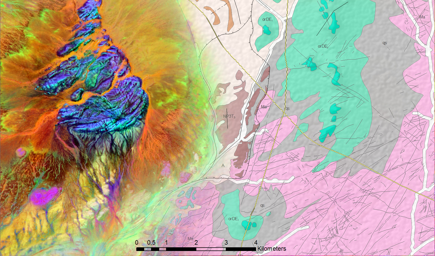
Combination Sentinel 2 / Geological map:
On the left side: Sentinel-2 principal component analyses shows a hydrothermal altered basement outcrop covered by sand sheets. The Geological map on the right side is highlighting the dyke swarm (black lines) cutting the basement (pink) and covered by Ordovician sediments (green and dark brown).
Produced using modified Copernicus Sentinel data of 2016 and 2017.
Credits: GAF AG
Disclaimer:
The views expressed herein can in no way be taken to reflect the official opinion of the European Space Agency.
Diese Pressemitteilung wurde via Mynewsdesk versendet. Weitere Informationen finden Sie im Aigner Marketing & Communications
Shortlink zu dieser Pressemitteilung:
DB Connection Error...Please try again in a few minutes.
Permanentlink zu dieser Pressemitteilung:
http://www.themenportal.de/wissenschaft/gaf-demonstrates-improved-geological-mapping-with-sentinel-data-84209
Themen in diesem Fachartikel:
Unternehmensinformation / Kurzprofil:
About GAF AG Germany
GAF AG is an e-GEOS (Telespazio/ASI) company located in Munich and Neustrelitz, Germany. It is a leading solutions-provider with an international reputation as a skilled supplier of data, products and services in the fields of geo-information, satellite remote sensing, spatial IT and consulting for private and public clients. GAF offers solutions in the sectors of mining and geology, natural resources, water and environment, security, land, agriculture, forestry and climate change. Since 1985, the company has been active in more than 1000 projects worldwide. For more information, please visit www.gaf.de.
Aigner Marketing & Communications
Birgit Aigner
Rumfordstraße 29
80469 München
info(at)aigner-marketing.de
089 543 44 065
DB Connection Error...Please try again in a few minutes.
Datum: 11.04.2018 - 15:20 Uhr
Sprache: Deutsch
News-ID 1599317
Anzahl Zeichen: 0
Kontakt-Informationen:
Ansprechpartner: Birgit Aigner
Stadt:
München
Telefon: 089 543 44 065
Kategorie:
Kunst & Kultur
Anmerkungen:
Dieser Fachartikel wurde bisher 60 mal aufgerufen.
Der Fachartikel mit dem Titel:
"GAF DEMONSTRATES IMPROVED GEOLOGICAL MAPPING WITH SENTINEL DATA
"
steht unter der journalistisch-redaktionellen Verantwortung von
Aigner Marketing& Communications (Nachricht senden)
Beachten Sie bitte die weiteren Informationen zum Haftungsauschluß (gemäß TMG - TeleMedianGesetz) und dem Datenschutz (gemäß der DSGVO).


